File:Bombaymapconfirmed attacks.png

預覽大小:577 × 600 像素。 其他解析度:231 × 240 像素 | 462 × 480 像素 | 905 × 941 像素。
原始檔案 (905 × 941 像素,檔案大小:222 KB,MIME 類型:image/png)
| 描述 |
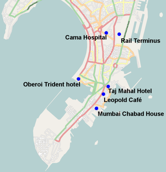
English: Map of the fairly solidly confirmed locations of the 26 November 2008 Mumbai attacks except Vile Parle suburb which is too vague and the port attack which again is still unclear also missing is the police station where it is unclear which one came under attack |
| 日期 | |
| 來源 | open streetmaps with modifications http://www.openstreetmap.org/?lat=19.0072&lon=72.865&zoom=12&layers=B000FTFT |
| 作者 | user:geni open street maps |
| 授權許可 (重用此檔案) |
Creative Commons Attribution-ShareAlike 2.0 |
| 描述 | Map of Mumbai. This map may be incomplete, and may contain errors. Don't rely solely on it for navigation. |
| 日期 | See file history |
| 來源 | OpenStreetMap data |
| 作者 | OpenStreetMap contributors |
| 授權許可 (重用此檔案) |
All OpenStreetMap data and maps are Creative Commons "CC-BY-SA 2.0" licensed. 此檔案採用創用CC 姓名標示-相同方式分享 2.0 通用版授權條款。
|
檔案歷史
點選日期/時間以檢視該時間的檔案版本。
| 日期/時間 | 縮圖 | 尺寸 | 使用者 | 備註 | |
|---|---|---|---|---|---|
| 目前 | 2008年11月28日 (五) 02:13 | | 905 × 941(222 KB) | Geni | {{Information |Description={{en|1=Map of the fairly solidly confimed locations of the 26 November 2008 Mumbai attacks except Vile Parle suburb which is too vague and the port attack which again is still unclear}} |Source=open streetmaps with modifications |
檔案用途
下列8個頁面有用到此檔案:
全域檔案使用狀況
以下其他 wiki 使用了這個檔案:
- ar.wikipedia.org 的使用狀況
- ckb.wikipedia.org 的使用狀況
- da.wikipedia.org 的使用狀況
- de.wikipedia.org 的使用狀況
- en.wikipedia.org 的使用狀況
- en.wikinews.org 的使用狀況
- fa.wikipedia.org 的使用狀況
- fy.wikipedia.org 的使用狀況
- he.wikipedia.org 的使用狀況
- hi.wikipedia.org 的使用狀況
- ja.wikipedia.org 的使用狀況
- kn.wikipedia.org 的使用狀況
- li.wikipedia.org 的使用狀況
- mai.wikipedia.org 的使用狀況
- ml.wikipedia.org 的使用狀況
- nl.wikipedia.org 的使用狀況
- pa.wikipedia.org 的使用狀況
- simple.wikipedia.org 的使用狀況
- tr.wikipedia.org 的使用狀況
- uk.wikipedia.org 的使用狀況